

Could it Happen Here?
Could it Happen Here?
Lessons from a biblical flood in North Carolina

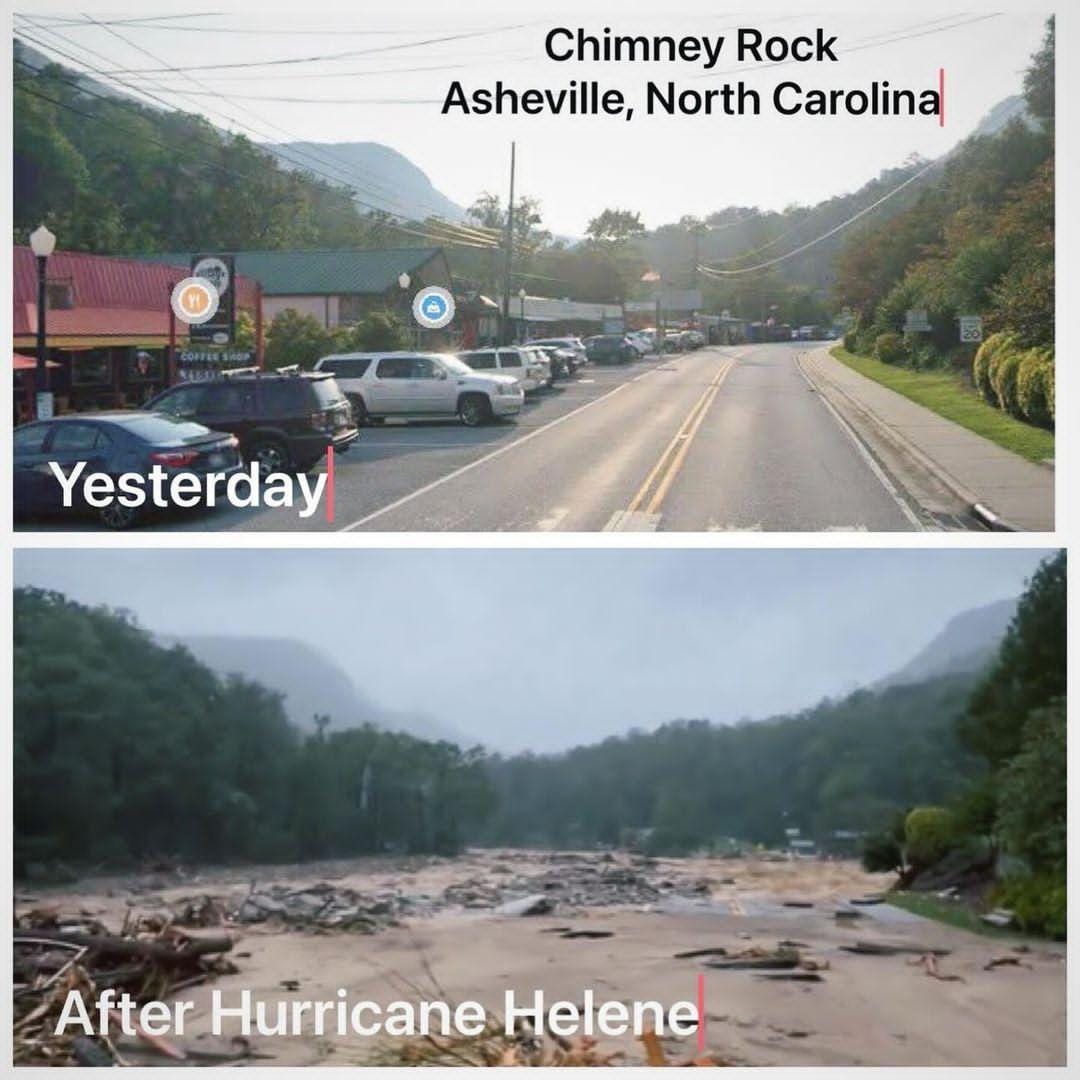
The images of devastation coming out of the flooding associated with Hurricane Helene are just jaw dropping. The tropical storm grew to hurricane strength and then travelled across at least six Southeast US states, from Florida up to Georgia, leaving chaos and destruction in its wake. Many communities along the path of destruction have seen biblical damage. Over 100 deaths have been reported so far (with warnings that the death toll could be hundreds more). Early cost estimates peg the Helene’s total cost at over $110 billion USD.
While the storm has now passed and floodwaters have subsided, two million people remain without power, and the electrical infrastructure is so junked in some places that it could be weeks, if not months, before it is fully repaired. There are shortages of clean water, thousands of people in shelters, and in the heaviest hit areas there are some communities with no easy way in or out, as the roads and highways have been washed away. Needless to say, this is one of the worst storms in American history.

Before the storm, all eyes were on Florida, where NOAA was warning about the potential for 20-foot storm surges along the coast. 20 feet! But few expected that Buncombe County, a bucolic area hundreds of miles to the North in the Western part of North Carolina, would become a second epicentre of this Hurricane’s destruction.

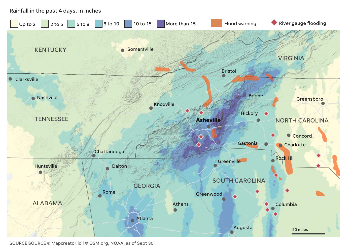
As Jeff Berardelli, Chief Meteorologist and Climate Specialist from Tampa Bay’s WFLA-TV later explained, the flooding in North Carolina was caused by “tropical moisture being forced into mountainous terrain… First, a ‘predecessor event’ saturating the ground, and then a fast moving hurricane slamming into the mountains, spiking rain rates”. In other words, the area got pummelled by two combined weather systems, for hours on end with more than 15 inches of rain! (That’s 381mm; Note: Here in Quebec we receive a ‘Rainfall Warning’ from Environment Canada if more than 50mm is expected within a 24 hour period). [Update: Just heard on the New York Times’ Daily podcast that some areas received 30 inches of rain - that’s 762mm… Just mind-boggling].
Reminds me of home!
I have to say that the small towns in Buncombe county dotted around Asheville (which itself is a mid-sized city of nearly 100,000 people) and nestled in the Southern Appalachians remind me of home here in the Gatineau Hills. The soft rolling hills, forested areas interspersed with farmland; the small town charm; the numerous creeks and rivers criss-crossing through the villages. It has a certain familiarity.
There’s also another link between the Gatineau Hills and Buncombe County. The Asheville areas has largely been interpreted to be a “climate haven” - a place where many people have been moving to as a place safe from many climate-intensified disasters, like wildfires, hurricanes, coastal erosion, the urban heat island effect, etc. This video from two years ago reported how people were moving to Asheville to “escape more severe climate change impacts” elsewhere in the US. Of course, I can’t say for certain people have moved to the Gatineau Hills to specifically seek out a “climate haven”, but so far, the area has proven to be one… mostly. We have of course not been immune to extreme weather here, or even floods, but then again, no place has, including Asheville (which has also had some major historic floods before).

Could It Happen in Wakefield?
But all of this had me wondering: Could something like what we saw in Buncombe County happen here? If so, what might it entail?
To answer this question we have to contextualize just how extreme this event was. It was at the very least a ‘100-year’ rainfall event, with flooding on the Swannanoa River (which traverses across Buncombe County) peaking at 26 feet - topping out the prior record from the early 1900s by more than 10 feet! There’s also the hurricane and ‘predecessor event’ double-whammy effect. While we DO have hurricane remnants reach us here in the Gatineau region, often they’ve shed a good amount of their moisture by the time they get here. So it would be quite rare to have a similar ‘one-two’ punch so far away from the Atlantic Ocean. We’d likely have to experience a similar combined effect of: a) a heavy rain event compounded by b) a tropical storm system, and c) a stalling of the system over the hills. Unlikely, but not impossible.
The all-time record for our region for a single day’s rainfall (based on Ottawa’s records) is currently 135mm in 24 hours (in 2004). If we get two days of that - again, unlikely, but not impossible, especially since climate change is increasing the likelihood of heavy rain events in this area - we start getting close to the amount of rain most people saw in Buncombe. If it comes during what is already a particularly wet season, with the ground already saturated, or if it comes in late winter/early spring when the ground is still frozen or covered with ice/snow, we could be looking at similar types of impacts - rivers and creeks and road-side ditches overflowing, roads eroding, infrastructure damage. Since we also live in a hilly area, there’s a compounding effect in low-lying areas as water runs off the mountainous terrain.
We have flood maps for this type of analysis. Here’s what the potential overflow of the Gatineau River in the heart of Wakefield might look like in a 100-year flood scenario:
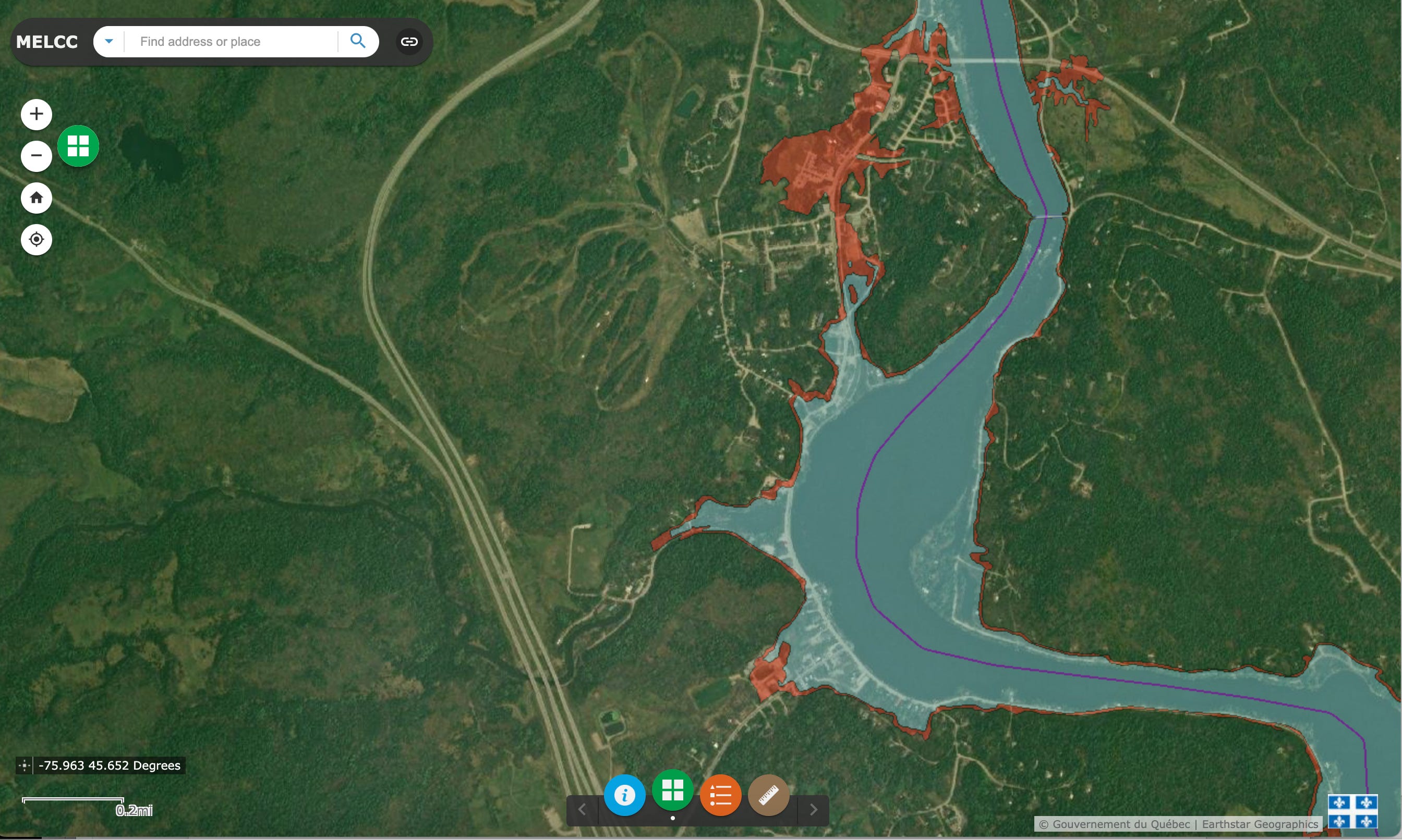
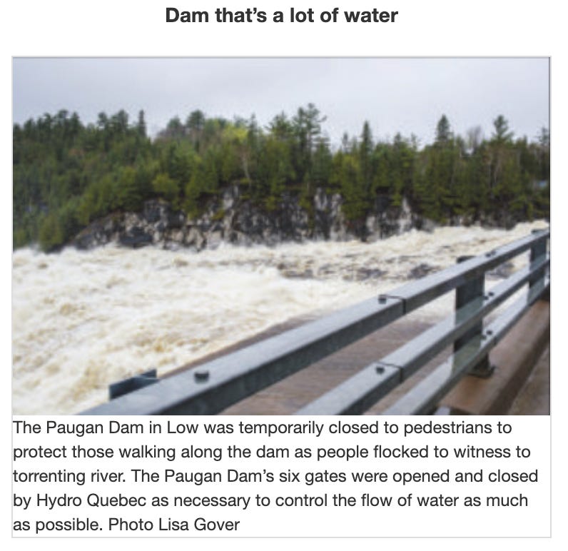
Important to note, this map only shows fluvial flood risks, associated with the overflowing Gatineau River. We’d also have to consider the potential for pluvial flooding (when an extreme rainfall event creates a flood independent of an overflowing water body). All this to say, the map only give a sense of part of the risks; there would likely be other flooded spots in low lying areas across the entire region. A potentially catastrophic addition in our case would be a breach or overflow of the Paugan Dam, in Low, upriver from Wakefield. [Some in the area may recall heavy rain in 2017 which led the Dam operators to open all six gates for safety purposes].
Community Preparedness
While a similar type of catastrophe is unlikely here in the Gatineau Hills, I think it’s worth thinking through as a community what we might do, where our vulnerabilities lie. For one, Wakefield village would be in deep trouble (no pun intended). As I wrote in this Climate Risk Assessment for the municipality: “Many properties along the Gatineau River waterfront in La Pêche are located on [historic] flood plains, including numerous buildings in downtown Wakefield village (including the Residence Le Manoir - Wakefield). This poses a significant risk to residents and first responders in the event of extreme flooding. Due to a lack of secondary access points in Wakefield village, residents could be unable to evacuate buildings, and first responders would have difficulty accessing buildings.” The risk also extends up and down the river, and poses a significant challenge to the North of Wakefield village in spots where Highway 105 hugs the river. In a case of extreme flooding, parts of the highway could wash out, and this would make it very difficult to travel into or out of the area. The Wakefield Police Station and Fire Hall BOTH would be at elevated risk of flooding themselves, given their proximity to the river.
All this to say, I think it’s worth it for emergency responders, the municipality, and the community to sit down together and really think through a ‘worst-case’ scenario like this, and keep our fingers crossed that we never have to resort to the emergency plans we draw up for such a scenario. How would we ensure access and egress to Wakefield Hospital? Would we set up a community shelter in Wakefield Community Centre - what if that building itself floods? Where would we set up stations to provide clean drinking water? How would we evacuate the Seniors’ residence, and where do those residents go? Who has boats or other watercraft that we could use to rescue people trapped in inundated homes? Who has back-up generators and/or space to house community members in need? How would we get fuel and food and electrical power in to the community if the highways and the electrical infrastructure are damaged? Who are our most vulnerable citizens, and how do we check in on them? These are scary questions, to be sure, but ones I’d rather contemplate in advance in a theoretical context, rather than in the moment of an emergency.